Browse items
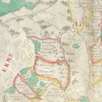
A seventeenth-century political map of Ireland from 1603-1625 capturing Lough Derg and Purgatory

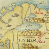
This chart, from an atlas by an unknown chartmaker probably working in Venice, shows an awareness of most of the eastern and southern coastlines of the British Isles stemming from voyages of Venetian galleys to the area since 1300.
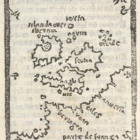
This is a map of the British Isles. It is a wood cut and is by the Venetian Pietro Coppo.
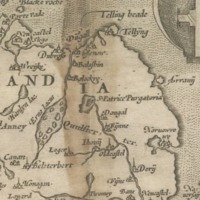
This map of the British Isles is by Gerard De Jode
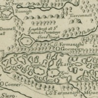
This is a map of the six "escheated" counties of Ulster.
A map of the British Isles dating from the period 1534-46 and by an unknown draughtsman.
The watershed, geology and wildlife of the Lough Golagh and Breesy Hill Special Area of Conservation
The watershed, geology and wildlife of the Tamur Bog Special Area of Conservation
The watershed, geology and wildlife of the Croaghonagh Bog Special Area of Conservation
The watershed, geology and wildlife of the Lough Eske and Ardnamona Wood Special Area of Conservation
The watershed, geology and wildlife of the Lough Nageage Special Area of Conservation
Located on the NW side of a tower house (DG105-014001-) and associated with a settlement cluster (DG105-014002-). The lands of Termon McGrath were granted to James, son of Archbishop Myler McGrath in 1610 (Hill 1877, 183-4). In 1611 Carew records…
Inishgarve or Moylederg Island was partially excavated (Davies 1946, 92-9). The island is natural but was possibly partially extended including the building of a landing quay. Objects recovered during the excavation ranged from Neolithic flintwork to…
The following description is derived from Cody (2000). The ‘stone circle complex at Cashelenny, County Donegal, is sited on bog-grown upland some 10 km. north-east of Pettigo . . . . The site was known to Oliver Davies who conducted fieldwork in…
Marked on the 2nd edition of the OS 6-inch map as a 'church in ruins', there is now no trace of the church above ground. In the surrounding graveyard (DG105-003003-), there are several grass-grown mounds. O'Connor (1879, 17) says that the church was…
A description by O'Connor of the pilgrim path from Castlederg to Lough Derg
A description by O'Connor of the pilgrim path from Donegal Town to Lough Derg
Dimensions 26m NE-SW, 11m NW-SE. An oval island in Lough Nageage apparently artificially constructed of stones although possibly on a natural rock base. At the N end is a stone wall, .8m high and 1.3m wide, partially under water. Bisecting the island…
An island in Bannus Lough 9m E-W × 6.5m N-S appears to have been artificially constructed. The lake level has risen submerging part of the island which appears as a cairn of stones in the water 18.6m E-W overall. A low stone wall is visible on the E…
An apparently natural island 29m × 15m in Lough Ultan appears to have some evidence of structural remains on its NNW side. The above description was derived from the 'Archaeological Survey of County Donegal. A description of the field antiquities…
Rathnacross (DG105-002001-), a circular area enclosed by a stone and earthen bank c. 0.5m high. A gap in the NE sector affords the only possible site for an entrance. There is a semicircular hollow (2.5m in diam. and 0.8m deep) in the SE quadrant…
A poem by J. Patton on Lough Derg from the Schools' Collection
A description of the Killeter Forest Bogs and Lakes Area of Special Scientific Interest (ASSI)
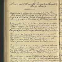
"The Friary is a townland on Killymard ([Cill O mBárd]) side of Lough Eske. It was here the Friars settled when banished from Donegal and ministered to the spiritual wants of the neigh-bouring districts. There is now no sign of a church or…
"There is a moat or mound in the townland of Cullion where a woman named Sabina did penance on the way to Lough Derg. She used to sleep on this mound the night before she went no matter whether the weather was wet or dry. It is still called Sibby's…